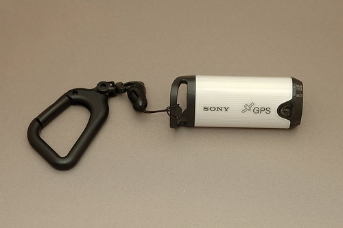
The Sony GPS-CS1 device
The
Sony GPS-CS1 is
a small device you can carry with you while walking around to record
your position. The device is small, relatively cheap (130EUR in 2007 in
Europe, taxes included), operates more than 10 hours on a single AA
battery. The GPS records a text file (ascii) using the NMEA format (see
for instance a description of that standard here: http://en.wikipedia.org/wiki/NMEA
).
From
a performance perspective, you have to know that it takes up to a bit
more than a minute for the device to find satellites. You need to be
patient before the actual tracking can start. My car navigation systems
usually are operational after a few seconds. Once the satellites are
locked, the tracking is working pretty well. Only when you are in areas
with high buildings or trees, you'll lose the link but the device is
recovering pretty fast after a reasonably short interruption.
The
device comes with a thin USB cable to connect it to your PC. It will be
recognized as a USB key (capacity is 32MB) and the tracking file will
appear as a normal
text file. The software package delivered with the GPS will allow to
record the location information in the exif part of your pictures.
Since
the principle is that location is determined thanks to the exact moment
at which the picture has been taken, it is important that your camera
has the right time. Precision is really paramount if you want accurate
positioning (don't forget to set it according to the right time zone
you are in). What I am doing is to synch my watch using a time
reference like (for GMT of course) http://wwp.greenwichmeantime.com/home.htm
and then to synch my camera with my watch with a one second precision.
The
GPS is recording the position every 15 seconds. My first test was like
45 seconds off and I was walking to take pics. You could see the delta
on the maps (50-100m approximately).
The Sony software (GPS
Image Tracker) is writing the GPS info in the JPEG files based on the
time the pictures have been taken. If you then upload your pictures to www.flickr.com for
instance, the picture will be positioned automatically and an option
"show on MAP" will appear when visualizing the picture. You can zoom in
and the result is amazing... you actually see more or less what you
photographed on the satellite picture.
One VERY IMPORTANT
thing related to flickr, you have to activate the GPS location
information processing in your settings BEFORE you upload pictures
otherwise the function will not work. You must use the following link
to activate: http://flickr.com/account/geo/exif
A
limitation of the Sony kit is that the Motion Picture Preview package
is just an update, you need a Sony camera like the Alpha to have that
software. If you have a license, you can upgrade and then immediately
position your pictures on a map. I heard that there was a specific
version of the kit called GPS-CS1KA which might contain the license but
it is not available in all countries (yet?) at this moment.
Otherwise
there are other possibilities to get the same functionality, as is
being explained in this excellent site:
http://www.gpspassion.com/fr/articles.asp?id=218
Another
interesting link (in fact the site that convinced me to buy the Sony
kit);
http://scilib.typepad.com/science_library_pad/2006/09/my_review_of_th.html
Some
information about the NMEA "standard" (it is a proprietary system)
http://www.gpsinformation.org/dale/nmea.htm
And
some more information about software and other related stuff (to geotag
pictures)
http://www.makezine.com/blog/archive/2005/07/how_to_gps_tag.html
The
Robogeo package (another solution to convert geocoded pictures)
http://www.robogeo.com/home/
The
Sony device can also be used to track your position and to display your
route on google earth or any comparable system (not need to take
pictures :D).
Software packages to show your route on a map
can be found here:
http://www.gpsvisualizer.com/map?output_wifi
if
you 've google earth plus, you can convert the log using GPSBabel and
see the route in google earth. GPSbabel is included in google earth,
but command line only. There is a GUI version in http://www.gpsbabel.org/
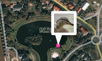
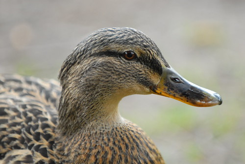
Here
is an example:
this picture of the duck has been taken
in a
small park, at walking distance from my home. I could immediately see
the
place in flickr using yahoo maps (logical since flickr is owned by
yahoo). This was an amazing experience because it was EXACTLY the
place where I took the picture... really amazing.
The
location in flickr:
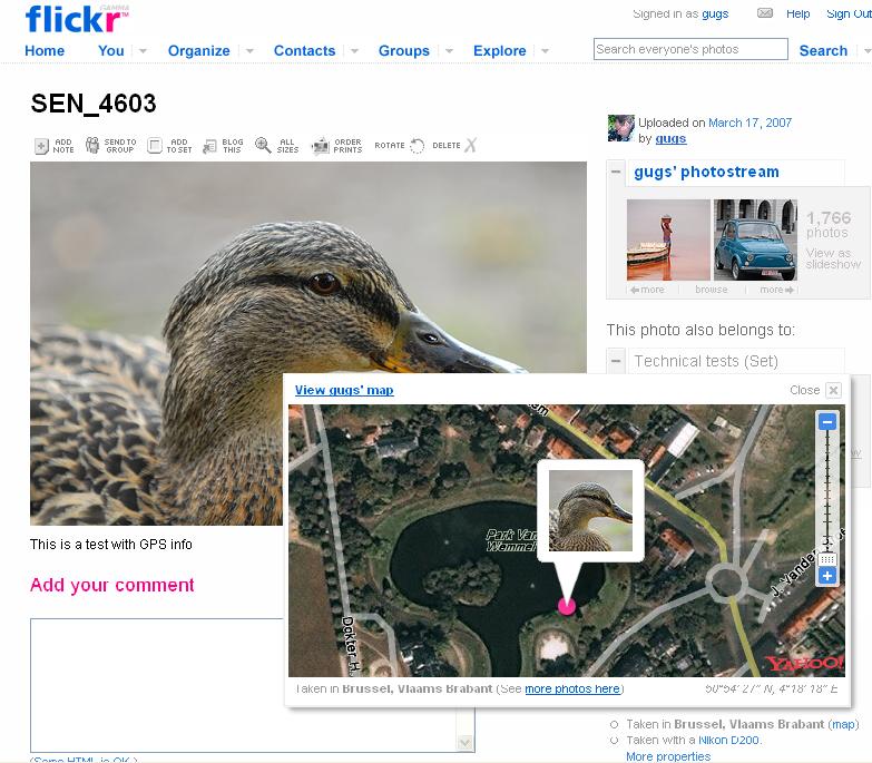
The
detail view: